
Relocation Theory
In May 2011, Brent Lane of the First Colony Foundation was studying the Virginia Pars Map, which was made by John White (see image below) during his 1585 visit to Roanoke Island, and noticed two patches where the map had been corrected. The patches were made of paper similar with that of the map. Lane asked researchers at the British Museum in London, where the map has been kept since 1866, what might be under the patches, sparking a research investigation. On May 3, 2012, at Wilson Library of the University of North Carolina at Chapel Hill, members of the Foundation and representatives of the museum announced the discovery of "a large, square-shaped symbol with oddly shaped corners." X-ray spectroscopy and other imaging techniques revealed that a patch hid a four-pointed blue and red star on the western end of Albemarle Sound. This symbol, presumed to represent a fort, is visible when the map is viewed on a light box.
"Our best idea is that parts of Raleigh's exploration in North America were a state secret, and the map 'cover-up' was an effort to keep information from the public and from foreign countries," said Eric Klingelhofer of Mercer University in Macon, Georgia, a historian and the principal investigator on the project.
"It's a very strategic place, right at the end of Albemarle Sound," he said. "You can go north up the Chowan River to Virginia or west to the Blue Ridge Mountains. They were big trading partners" with other Native American tribes. Some scholars speculate that the colonists relocated to that location, on what is now called Salmon Creek in the Bertie County community of Merry Hill. The Scotch Hall Preserve golf course community was planned on the site, but it has not been fully developed.
Archaeologist traveled to the community of Merry Hill, and began digging for artifacts. Slowly, the pits gave up their secrets. In just the small areas excavated, the hillside has yielded an unusually high concentration of Border ware (a type of ceramic) and other colonial artifacts, such as a food-storage jar called a baluster, a hook used to stretch hides, a buckle, and pieces of early gun flintlocks called priming pans. No signs of a fort or other structures have been found, but the aggregate of the artifacts convinced the archaeologists that at least a few of the colonists wound up there.
There are theories for other locations where colonists might have scattered to, including the one farther south, on Hatteras Island. That site has been known since the 1930s and in the past has yielded intriguing metal items such as a ring, part of a horse bridle, two 17th-century coins and part of the firing mechanism for a gun.
Over the last few years, a British archaeologist, Mark Horton, has led an excavation there. He, too, has found unusual artifacts, such as a rapier hilt, late 16th-century gun hardware and part of a slate writing tablet. Many of the 16th-century items were mixed in with artifacts from almost a century later, though, making it nearly impossible to date them. No Border ware pottery — a telltale sign of habitation — has been found on the Hatteras site.
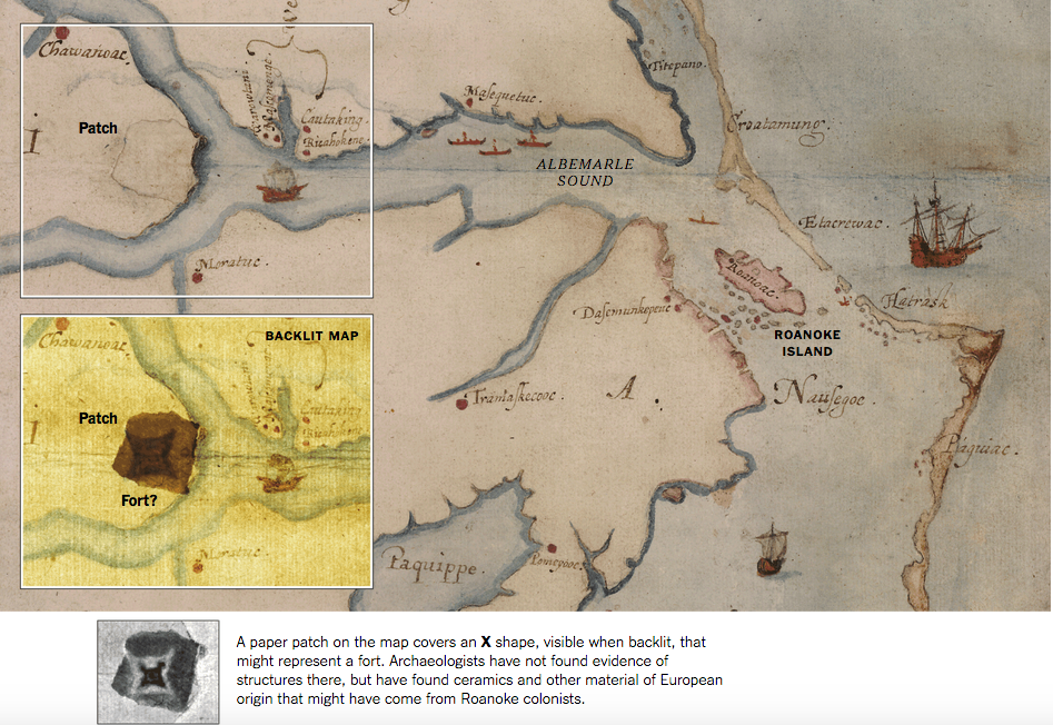
John White began drawing this map of Albemarle Sound around 1585.
